

OTTAWA COUNTY, Okla. — For decades, many residents of Ottawa County have contended with contaminated water and soil from the Tar Creek Superfund Site, one of the oldest of these sites in the nation. New data that was just released shows that risks are even greater than previously thought, according to a comprehensive geographic information system map or GIS map.
The new map was created by environmental organization, Local Environmental Action Demanded (LEAD) Agency through support from science nonprofit, American Geophysical Union’s Thriving Earth Exchange.
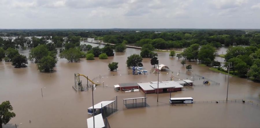
The map reveals that piles of toxic mining waste currently lie within the Tar Creek floodplain, leaving Ottawa County even more vulnerable to heavy metals contamination.
“That was what absolutely shocked us was what we didn’t know. When there’s flooding, those roads around Miami and inside the Tar Creek Superfund Site, are closed. We can’t get there when it’s flooded and no one had ever seen where the water floods go when we have major flooding events like what we saw in 2019 and also back in 2007. So, it’s a real eye opener to see those chat piles in the floodplain, sitting in water that flows in, and takes that material into the lakes and rivers that people in the area drink from. So this new map really shows what we simply couldn’t see during flooding events,” said Rebecca Jim, Executive Director of LEAD Agency.

LEAD Agency’s new map shows that when Tar Creek floods, the county not only suffers the impact of toxic creekwater, but also direct contamination from towers of toxic waste known as “chat,” which loom up to 200 feet over the landscape.
“The region has experienced increased flooding in recent years and will likely see more due to climate change,” said Jim.

The map project began in 2020, when Jim, a member of the Cherokee Nation, partnered with Thriving Earth Exchange to create a tool that could visually showcase what happens when Tar Creek floods. Jim’s primary collaborator was Community Science Fellow Jessica Tran, who worked with environmental scientists and cartographers to develop the interactive map that includes the specific locations of chat, aquifers, and groundwater wells, as well as the locations of Federal Emergency Management Agency (FEMA) assessed properties. Tran and Jim hope the map will spur the EPA to clean up Tar Creek, and alert local residents to imminent risks.
According to LEAD Agency, there are approximately 1,480 properties that exist in the floodplain. Jim says as people move to the area over the years, many may not realize the threat.
“People that have moved in may not know about where the flood waters can extend to, so there could be people that don’t know, and then there are people that recently had to buy flood insurance that never had to have it before. So I would say that there’s some great awakening happening,” said Jim.
“Homes that have been remediated may very well be re-contaminated, and climate change will continue to make things worse. With more frequent and unpredictable flooding, we need to clean up Tar Creek, so it is safe for residents of Ottawa County,” said Tran.
The new floodplain map is currently available HERE. LEAD Agency also plans to distribute a PDF version on flash drives at their annual Tar Creek Conference on Wednesday, October 12th and Thursday, October 13th at Northeast Oklahoma A&M College in Miami, Oklahoma. You can find more information about the Tar Creek Conference, HERE.
ABOUT L.E.A.D.
LEAD Agency is an environmental justice organization in northeastern Oklahoma that seeks to raise awareness about the effects of contamination on human health and the environment. Through public education, outreach, action, involvement with appropriate government agencies, and litigation, LEAD works to organize a citizen response toward cleanup and restoration of environmental harms, while striving for pollution prevention and environmental sustainability.