


— UPDATE 6:10 a.m. A Flash Flood Warning has been issued for the Charleston metro until noon Friday.

—
— UPDATE 5:41 a.m. St. Johns Fire District is reporting a large tree is down near 2300 Bohicket Road and blocking the roadway. SCDOT crews have been requested to assist.
—
MOUNT PLEASANT, S.C. (WCBD) – Ian re-strengthened into a Category 1 hurricane on Thursday as the storm set its sights on the South Carolina coastline.
Much of the Lowcountry began to feel impacts from the storm on Thursday by way of gusty winds, rain, and some coastal flooding. Those impacts are expected to increase through the day on Friday.
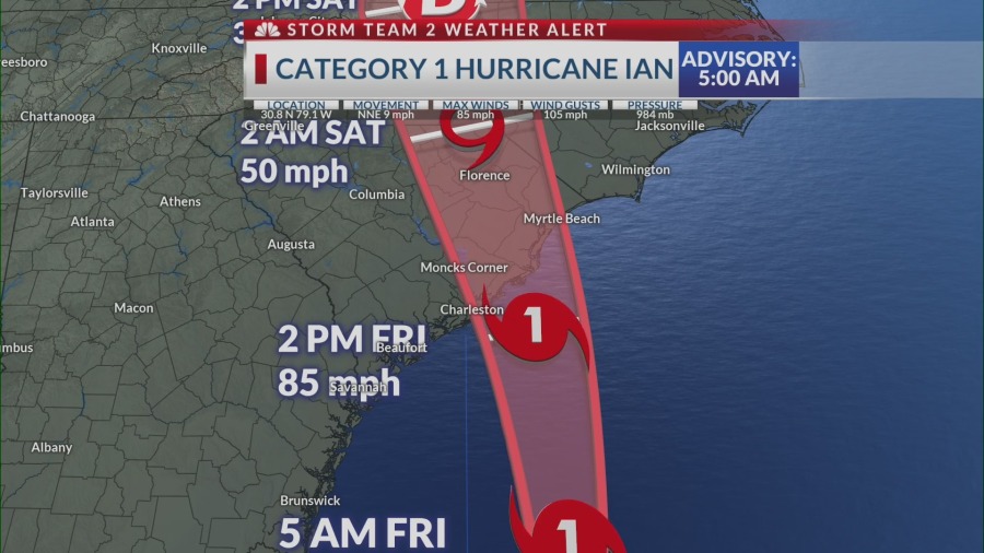
The National Hurricane Center (NHC) said in its 5:00 a.m. update that Ian was moving north-northeast at 9 mph with 85 mph sustained winds. The storm was located about 175 to the south-southeast of Charleston.
“It still looks like there will be a South Carolina landfall of a Category 1 hurricane somewhere from upper Charleston County all the way to Little River Inlet early Friday afternoon,” said Storm Team 2 Chief Meteorologist Rob Fowler.
Fowler said heavier rain bands began to move onshore after midnight Friday and will increase throughout the morning along with strong, gusty winds.
WHAT TO EXPECT:
Ian is expected to make landfall along the South Carolina coast somewhere between Charleston County and Horry County on Friday.
Serious flooding and storm surge is expected. Officials have urged those living in low-lying areas or barrier islands to seek shelter on higher ground.
The National Hurricane Center said that “the deepest water will occur along the immediate coast near and to the right of the center, where the surge will be accompanied by large waves.”
Tornados and waterspouts could form during the overnight hours.
Strong winds are expected to cause significant issues overnight Thursday through Friday. Downed trees, power outages, and unsafe driving conditions are all serious possibilities.
Gusts of up to 45 miles per hour in Charleston, 60 miles per hour in Mount Pleasant, and 44 miles per hour more inland in places like Summerville could be seen Friday afternoon.


WATCHES AND WARNINGS:
Hurricane Warning: Savannah, Georgia to Cape Fear, North Carolina.
Storm Surge Warning: Volusia County, Florida to Cape Fear, North Carolina
Tropical Storm Warning: Storm Surge Warning: Volusia County, Florida to Savannah, Georgia; Cape Fear to Duck, North Carolina
Storm Surge Watch: North pf Cape Fear to Duck, North Carolina; Pamlico River, Cape Fear River
Hurricane Watch: East of Cape Fear to Surf City
—
Forecasters say power outages and downed trees are likely due to the excessive rainfall and gusty winds associated with Ian. Be sure to download the News 2 app to receive weather alerts, breaking news, and watch News 2 live on your phone if you lose power during the storm.