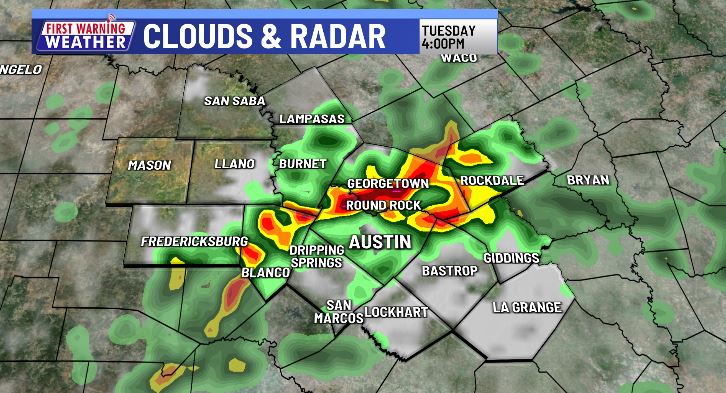

AUSTIN (KXAN) — Today is likely to be the wettest day of the work week with scattered to widespread rain leading to flooding concerns in Central Texas.
In the tropics, the National Hurricane Center is keeping a close eye on two areas in the Atlantic that have the possibility of developing into a tropical depression or stronger within the next 5 days. Should one of these areas become a tropical storm, it would get named Danielle. Not since 1997 have we gone the entire month of August without a named storm in the Atlantic Basin.
Though the tropics are heating up, none of these developing systems pose a direct threat to the Gulf Coast including Texas at this time.
FIRST WARNING WEATHER: Stay up to date with your Central Texas forecast, sign up for our weather newsletter at kxan.com/newsletters
Summer heat
Following Austin’s first official day of triple-digit heat, back on May 21, the First Warning Weather team each came up with their own predictions for how many 100° days we’ll see this year. Follow along through the summer with the chart below. Camp Mabry is in the midst of its hottest summer on record.
Other stories you may like
Sign up for our daily forecast newsletter at kxan.com/newsletters. Download the KXAN Weather app to get the latest weather forecast: Apple | Android
___________________________________________________________________________________________
Follow the KXAN First Warning Weather team on Facebook, Twitter and Instagram.
You can also follow our meteorologists’ individual accounts for livestreams and a little bit of what goes on behind the scenes: