AUSTIN (KXAN) — The weather has been quiet overnight with a mostly cloudy to overcast sky. Saturday’s rain ended during the early evening. The highest total in the area was .17″ at the gauge at the Colorado River in Austin. All other totals held under .10″.
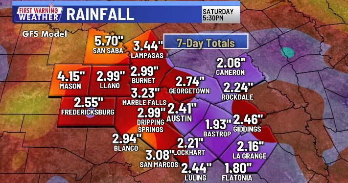
Future clouds and radar depict a few showers and thunderstorms possible along and east of I-35 this morning and afternoon with moisture becoming more plentiful from the low that moved from the Gulf onshore in northeast Mexico. A few pockets of heavy rain may produce totals of between .25″ and .50″. Most totals today will hold under .10″.
High temperatures will rise to the lower to middle 90s. Austin will not hit a triple-digit high like it did Saturday when, at 2:05 p.m., the temperature reached 101°. It is the 68th day of a high of 100° or higher, good for a tie for third place with 2009 for the most triple-digit highs in a year.

A trough in the upper atmosphere currently over the panhandle and west Texas will slide to the east increasing the chance of rain for our northern counties tomorrow morning. Again, there will be a few areas that are likely to see a few brief downpours. The afternoon looks to be wetter with moderate to heavy thunderstorms from the western Hill Country to I-35 extending into our eastern counties between 3 and 6 p.m.

A frontal boundary will combine with the tropical moisture already in place to keep rain chances high for Tuesday and Wednesday. Numerous showers and thunderstorms will affect the area resulting in a SLIGHT CHANCE for flooding as forecast by the Weather Prediction Center.

High temperatures between now and Friday will be primarily in the lower to middle 90s. Tuesday looks to be our “coolest” day with many highs between 86° and 90°.
Finally, the Climate Prediction Center is not changing its thinking for its 2-week outlook. It continues a forecast of “cooler than normal” and “wetter than normal” from August 28th through September 3rd.
We encourage to pay attention to the changing weather as it affects where you live. The KXAN Weather app is an excellent way to get the important weather information you need.
FIRST WARNING WEATHER: Stay up to date with your Central Texas forecast, sign up for our weather newsletter at kxan.com/newsletters
Farmers’ Almanac releases Texas winter forecast — Here’s why it’s probably wrong
Summer heat
Following Austin’s first official day of triple-digit heat, back on May 21, the First Warning Weather team each came up with their own predictions for how many 100° days we’ll see this year. Follow along through the summer with the chart below. Camp Mabry is in the midst of its hottest summer on record.
Other stories you may like
Sign up for our daily forecast newsletter at kxan.com/newsletters. Download the KXAN Weather app to get the latest weather forecast: Apple | Android
___________________________________________________________________________________________
Follow the KXAN First Warning Weather team on Facebook, Twitter and Instagram.
You can also follow our meteorologists’ individual accounts for livestreams and a little bit of what goes on behind the scenes:
