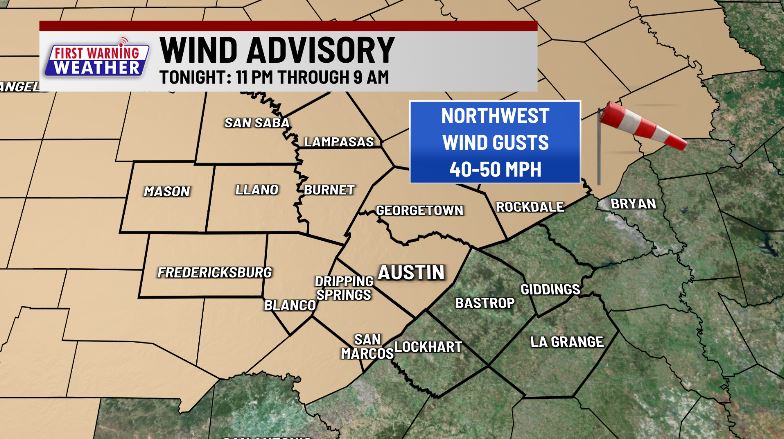

AUSTIN (KXAN) — Now that the severe threat has ended, our focus turns to strong winds this morning with gusts topping 40-50 MPH in some locations. A Wind Advisory continues through 9 AM – be mindful of power outages and knocked tree limbs while on your way into work/school.
Monday’s cold front triggered numerous Severe Thunderstorm and Tornado Warnings including a radar-estimated windspeed of 100+ mph just south of Jarrell. In this same area an 18-wheeler was flipped on I-35 forcing a brief halt of traffic. Roof damage was also reported to an estimated 50 homes and a Jarrell fire station had its garage doors and windows blown out, and part of its roof torn off.
Low humidity and strong winds combined with our ongoing severe drought will create conducive ingredients for the spread of fires. Much of the KXAN viewing area is in the ‘Very High’ category for wildfire danger through Tuesday afternoon.

Sunshine and mild temperatures can be expected through midweek with the coldest morning coming up Wednesday as lows drop to the middle to upper 40s.
Thursday night to Friday afternoon will be the next chance for more rain. Another cold front will move across leaving a dry northerly wind Friday afternoon.
2022 remains tied with 2011 for the highest 90° day count on record. High temperatures both Saturday and Sunday fell just short of breaking that record, reaching 89°. If Austin reaches 90° again anytime before the year ends, we will break 2011’s record.
FIRST WARNING WEATHER: Stay up to date with your Central Texas forecast, sign up for our weather newsletter at kxan.com/newsletters
Summer Heat
Meteorological summer ended on Aug. 31, as Camp Mabry recorded its second-hottest summer in recorded history. Austin-Bergstrom recorded its 7th-hottest summer on record.
Sign up for our daily forecast newsletter at kxan.com/newsletters. Download the KXAN Weather app to get the latest weather forecast: Apple | Android
___________________________________________________________________________________________
Follow the KXAN First Warning Weather team on Facebook, Twitter and Instagram.
You can also follow our meteorologists’ individual accounts for livestreams and a little bit of what goes on behind the scenes: